Chapter 04
About
The Dam Atlas is a guide for communities to understand, evaluate, and make decisions about historic dams.
New England is home to more than 14,000 dams, many of which are small, “legacy” structures built over a century ago. Most no longer serve their original industrial purposes and are reaching the end of their useful lives, raising concerns about safety, maintenance, and ecological impacts. These aging dams can threaten downstream communities, especially as climate change brings more frequent and intense storms. While dam removal is often advocated for ecological, economic, and safety reasons—such as restoring fish passage, water quality, and sediment flow—many communities feel a strong attachment to their local dams. Dams and their impoundments have become part of the landscape, local history, and sense of place, sometimes even serving as town landmarks or symbols of cultural identity.
The goal of this website is to share this work and support communities who are making decisions about the future of a dam. Decisions about dams are inherently complex and require the consideration of ecological, social, safety, and economic trade-offs. While there are many great resources and publications for proponents of dam removal, this website aims to provide an unbiased source of information on the ecological and social considerations associated with dam decisions. Rather than advocating solely for removal, the goal of this approach is to bring a community into an open conversation to think creatively about the future of a dam. While this may seem counterintuitive if your role is to advocate for dam removal, engaging communities in an open but structured discussion about the future of a dam has the potential to lead to better environmental outcomes and a community that has more ownership, connection, and sense of stewardship over their river. In addition, this approach has the potential to address what are often perceived as unequal power dynamics between dam removal proponents and the local community, which has led to projects stalling or failing in the past.
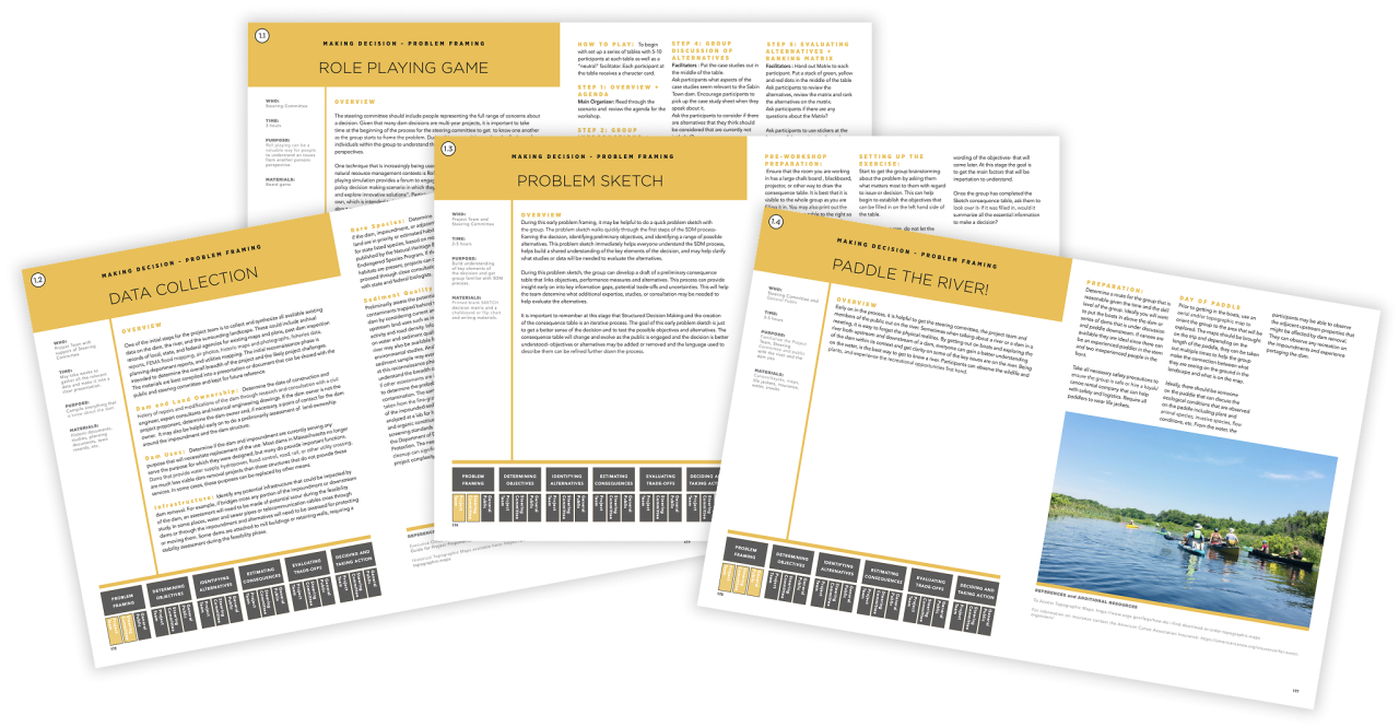
This website consists of four main sections: The first chapter, “Understanding Dams,” introduces key ecological, social, infrastructural, and economic factors that are important to consider for the management of dams at the individual and watershed scale. The second part, “Scenarios & Case Studies,” looks at various alternatives for the future of a dam and presents a series of case studies of projects throughout the region. The third chapter, “Making Decisions,” shares methods, ideas, and tools for how to engage in conversations about the future of a dam. The last section, the Interactive Dam Atlas, was developed in collaboration with faculty from the University of Rhode Island and helps to visualize and build a geographic understanding of dams in the Narragansett Bay and Rhode Island coastal watersheds.
While this Dam Atlas is focused on dams in the Narragansett Bay and coastal watersheds of Rhode Island, the metrics calculated in the GIS analysis can be applied to other watersheds, and the decision-making tools are not region-specific. By sharing our methods and the open-source decision support toolkit, the aim is to help support practitioners and communities that are looking for ideas, methods, and techniques for having discussions about the future of a dam. We encourage others to use, test, modify, evolve, and share these methods. Ultimately, the goal is for this work to contribute to a “library of approaches” that are openly shared to build knowledge and techniques to support collaborative environmental decision-making around dams.
Credits


This project is a collaboration between CommonPlace Landscape and Planning, The Rhode Island School of Design, and The University of Rhode Island with generous funding from the USDA Natural Resources Conservation Service, the National Science Foundation, Rhode Island Sea Grant, and the Blackstone Watershed Collaborative.
Project Vision and Content by Emily Vogler, GIS Analysis by Jason Parent, Content support by Art Gold and Ben Bailey, Website by Tanager Creative, Interactive Map Design and Development by Rubén Rodríguez.
Subscribe for periodic updates related to the Dam Atlas
"*" indicates required fields