Source: University of Massachusetts Amherst
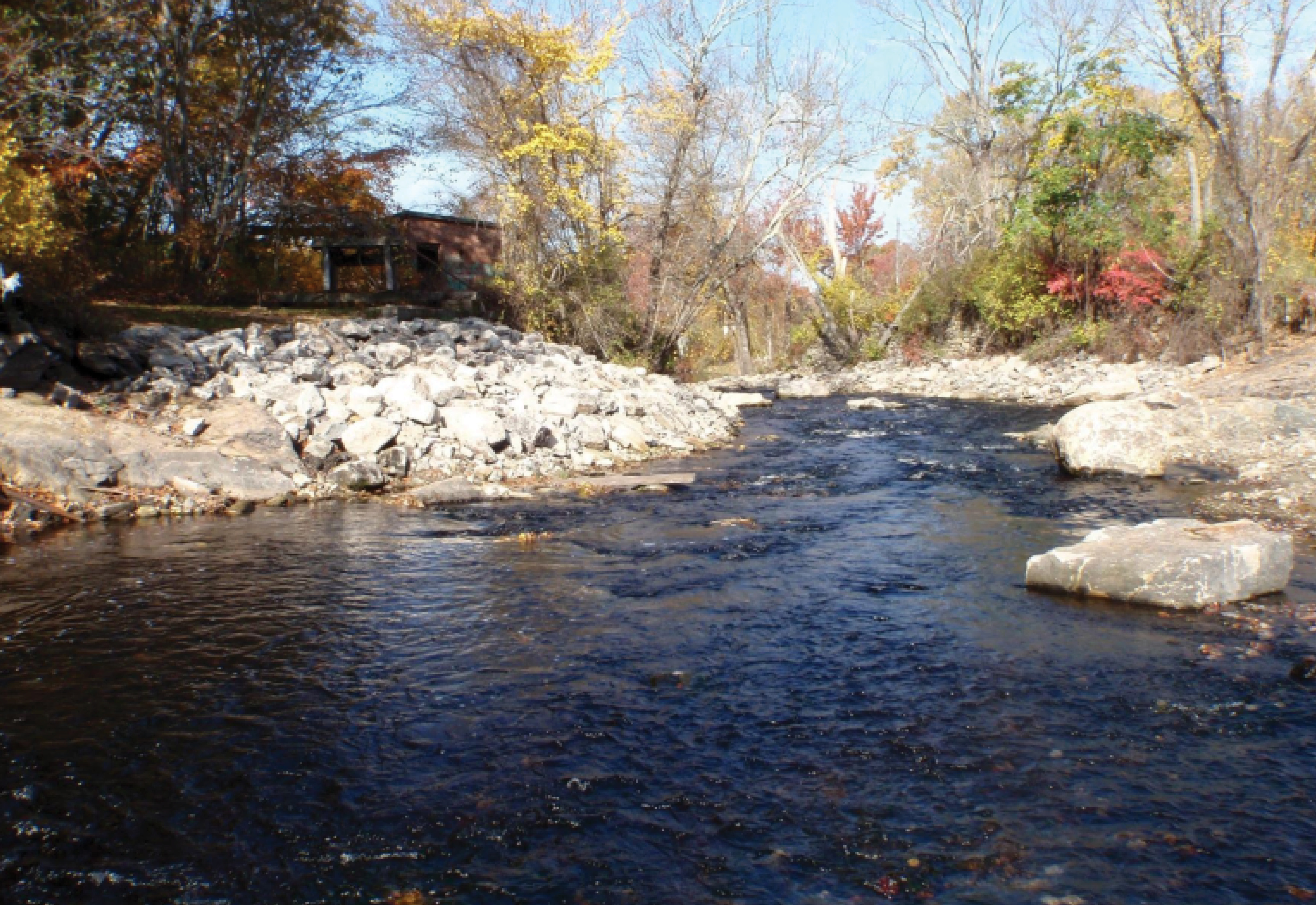
Case Study: Lower Shannock Falls Dam
Location: Charlestown/Richmond, Rhode Island
River: Pawcatuck River
Goal: Migratory fish passage
Type : Complete removal with Historic Signage and Artifacts
Dam Owner: Town of Richmond
Total project cost: $924,688
Year: 2010
Partners: Wood Pawcatuck Watershed Association; Trout Unlimited; United States Fish and Wildlife Service; RI Coastal Resources Management Council; RI Department of Environmental Management; National Oceanic and Atmospheric Administration; Save the Bay; Richmond Conservation Commission; Town of Richmond; USDA Natural Resources Conservation Service; American Rivers; and Narragansett Bay Estuary Program.
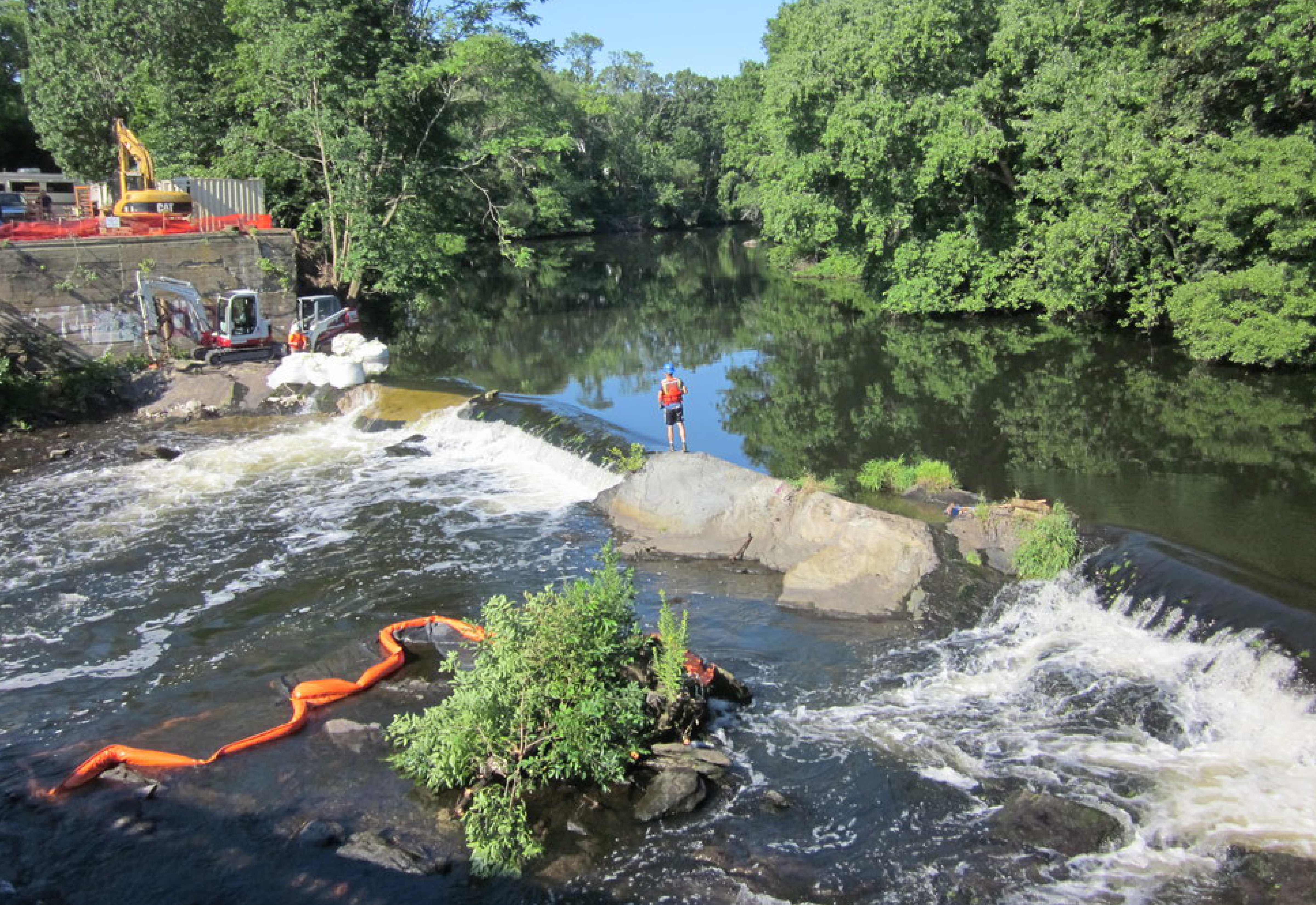
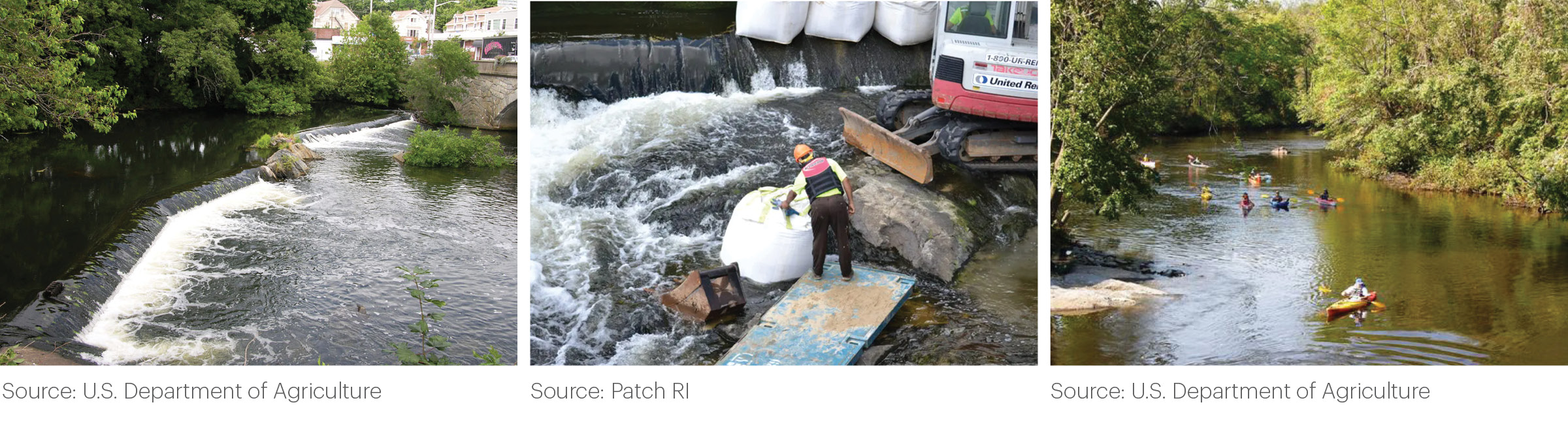
Context: Lower Shannock Falls Dam, located on the Upper Pawcatuck River between Charlestown and Richmond, was erected in the early 1800’s. This site contains historic significance to both the Narragansett Tribe and Anglo‐European communities. The Lower Shannock Falls dam removal was part of a comprehensive project that opened fish passage through seven dams along the Pawcatuck River.
Challenges: Initially, the neighboring community was not in favor of the design and construction that was needed for the dam to be removed. Some residents were worried that the diversion of the river during the construction process may have negative ecological impacts. Others were concerned that the site would not reflect its historical significance to both Anglo‐Americans and the Narragansett Tribe . Additionally, others were worried that when the dam was removed, the water would be too turbulent to permit recreational use.
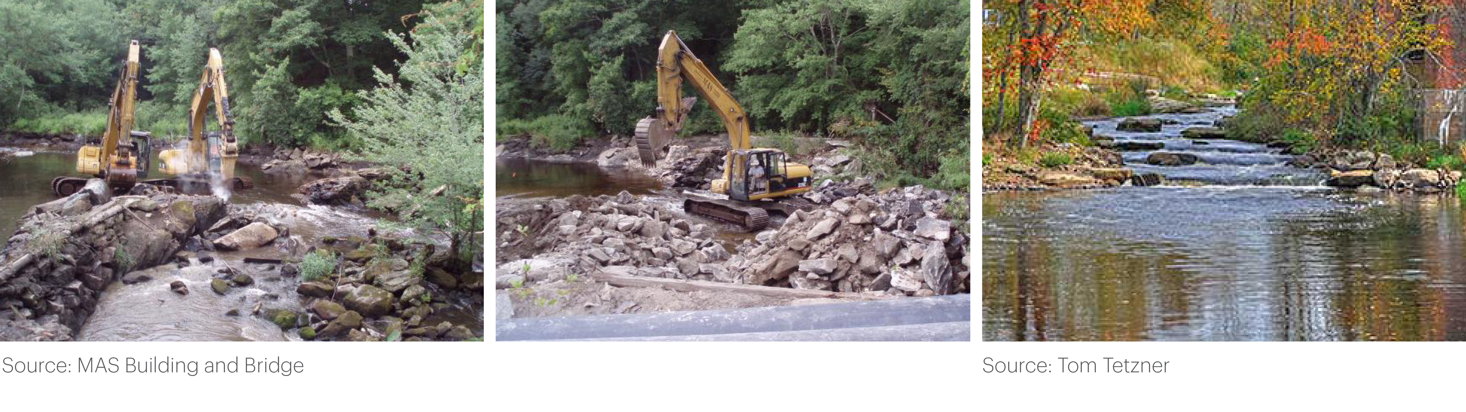
Solutions: In 2010, the dam was removed and three weirs were installed to ensure that river flows met the migratory needs of the fish. The Knowles Mill Public Park was developed by the town of Richmond on the river bank below the falls providing trails as well as fishing and boating access downstream of the former dam. The historic smoke stack from the mill was left in place and interpretive signs were installed in the park to document the historic and cultural importance of the area.
Successes + Lessons Learned : Throughout the project, the project team consulted with the local community and the Narragansett Tribe. This collaboration allowed for the historical preservation concerns of the community to be addressed while allowing for the dam to be removed. By creating a public park surrounding the old dam site, public access to the river was enhanced. The history of the site is communicated through the preservation of ruins as well as signage in the park that displays historic photos.
The project benefited from a team experienced in fishery biology, hydrology/hydraulics, sediment transport, and water management. Completing the weirs in “dry” conditions helped achieve elevations and other design features required for fish passage. Testing river flows during construction allowed site-specific modifications that would help fish in their migration up and down the river.
For more information, see NOAA’s presentation: “Advancing Anadromous Fish Passage Efficiency Lower Shannock Falls Dam Removal Pawcatuck River, Rhode Island”
Source: Save the Bay
Case Study: White Rock Dam
Location: Westerly, Rhode Island and Stonington, Connecticut
River: Pawcatuck River
Goal: Migratory fish passage; Flood abatement; Recreation enhancement
Type: Complete Removal
Dam Owner: Griswold Textile Print
Total Project Cost: $794,000
Year: 2016
Primary Partners: The Nature Conservancy; United States Fish and Wildlife Service; RI Coastal Resources Management Council; RI Department of Environmental Management; National Oceanic and Atmospheric Administration; the Wood‐Pawcatuck Watershed Association; and Save the Bay.
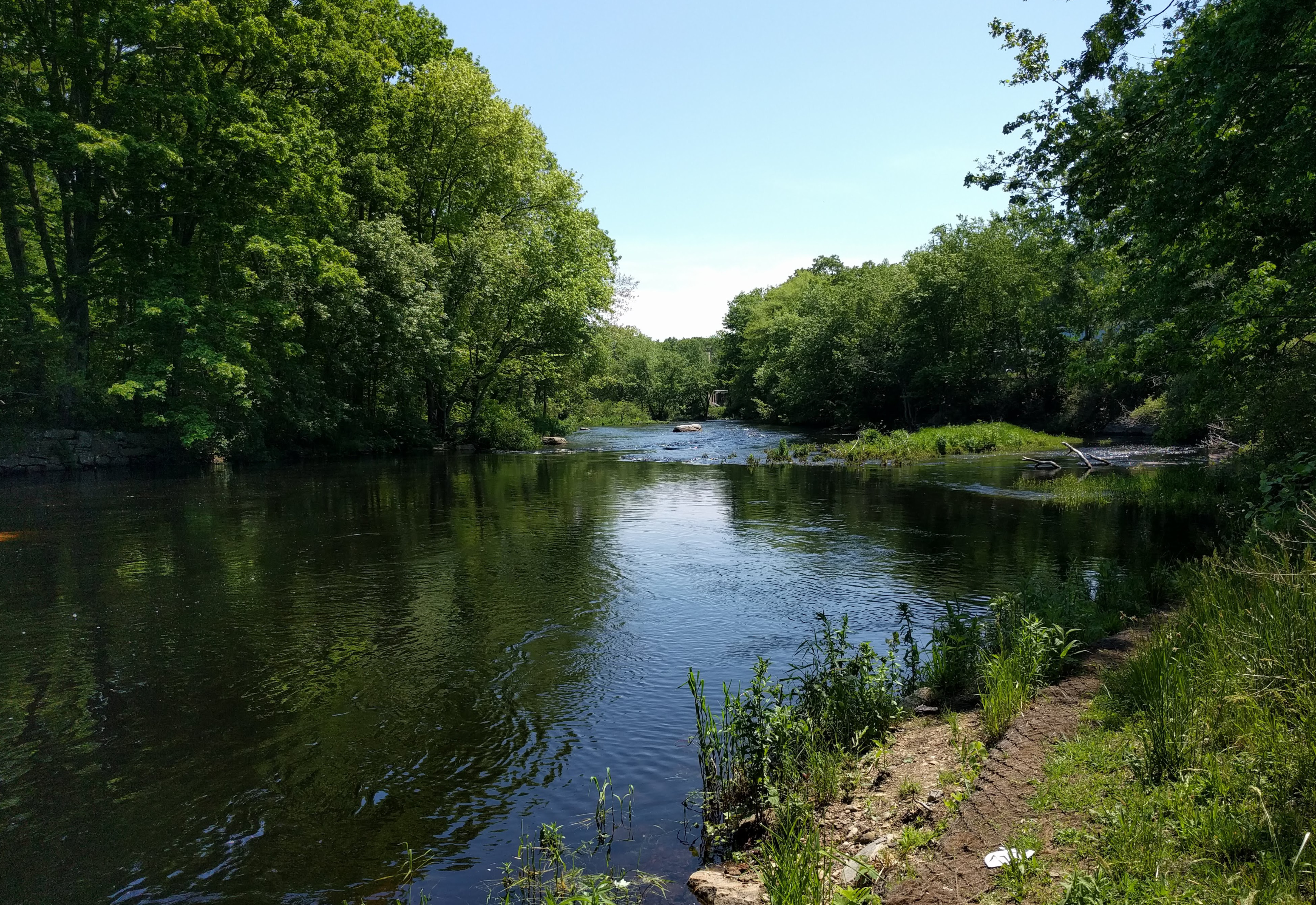
Context: For over 200 years, there have been dams at the mouth of the Pawcatuck watershed. In 1938, these historic dams were replaced by the White Rock Dam. It spanned 108 feet across the Pawcatuck River and stood six feet high. The dam blocked most fish passage from the Atlantic Ocean into the Pawcatuck River. Although a raceway was available to migrating fish, it only passed fish under perfect stream conditions; studies showed that only 15 percent of fish were able to battle through the strong currents in the narrow channel. Flooding was another significant concern. Major flooding in 2010 damaged the structure, causing it to become a safety hazard.
Challenges: White Rock Dam was privately owned and adjacent to three other properties. It spanned across the Connecticut and Rhode Island border. One of the greatest challenges was that the dam was under the jurisdiction of two states.
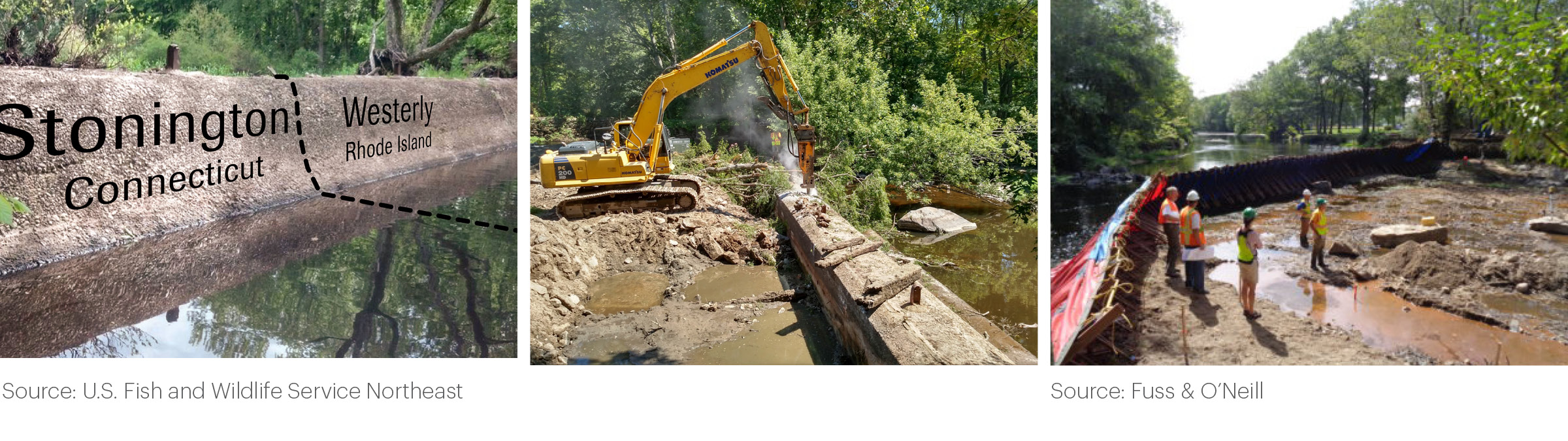
Solutions: The removal of the White Rock Dam required stakeholder and decision-maker integration across both states. The owner of the dam, who would be liable for damages if the dam were to fail, allowed the removal of the dam. There was no significant push back from the owners of the other adjacent properties. Working across state boundaries provided significant permitting challenges, but coordination between government agencies and environmental organizations in both states allowed the process to move forward. Two separate filings — an 800-page application in Connecticut and a 650-page application in Rhode Island — resulted in approval of the dam removal permits.
Successes: Removal of the dam eliminated a hazardous structure, which minimized possible flooding downstream while allowing diadromous fish species to regain passage to and from the ocean. The White Rock Dam was the first dam blocking migratory flow from the Narragansett Bay through the Pawcatuck River. The removal of the dam spurred subsequent projects upstream.
Lessons Learned: Cooperation with other agencies is necessary especially when working across state boundaries: Sally Harold, from the Connecticut chapter of The Nature Conservancy, stated, “A lot of it means we have twice as much work to do. We have two agencies to work with, but it also means we can double‐dip fisheries biologists from both sides, from both agencies, and there’s been great cooperation between agencies and other project partners from both sides of the river.”
Source: Ruth Horowitz
Case Study: Pawtuxet Village Dam – Partial Dam Removal
Location: Cranston and Warwick, Rhode Island
River: Pawtuxet River
Goal: Migratory Fish Passage
Type: Partial Removal
Owner: Pawtuxet River Authority
Cost: Approximately $1,000,000 including permits, engineering, and project management; construction cost of approx. $800,000
Year: 2011
Primary Partners: Pawtuxet River Authority & Watershed Council (PRA); Narragansett Bay Estuary Program; USDA Natural Resources Conservation Service; RIDEM; RICRMC; The Rhode Island Foundation; USEPA; National Oceanic and Atmospheric Administration; US Fish and Wildlife Service; American Rivers; Save The Bay; RI Saltwater Anglers Association; Friends of the Pawtuxet; Pawtuxet Village Association; City of Cranston; City of Warwick; Restore America’s Estuaries; RI Rivers Council; RI Corporate Wetlands Partnership; Rhodes‐on‐the‐Pawtuxet; Hunter’s Garage 66.
Context: In the 19th century, dams constructed along the Pawtuxet River helped to power Rhode Island’s textile industry. Years of industrial use, including the release of untreated chemicals from the Ciba-Geigy chemical plant, left the river heavily polluted. Poor water quality led to declines in fish population and river access for the local community. After decades of investments aimed at improving water quality and habitat in the river, the decision was made to remove the Pawtuxet Falls Dam. For hundreds of years, the Pawtuxet Falls Dam blocked migratory fish passage as the first of many dams leading from the Narragansett Bay through the mill towns situated along the river.
Challenges: There were multiple hurdles that needed to be overcome before the dam could be removed. Design issues were complicated as stakeholders wished to minimize changes to the river’s morphology. However, bedrock in the area was not stable enough to safely navigate river herring upstream and allow for a full dam removal. The water quality and sediment were degraded by more than a century’s worth of upstream discharge of human and industrial waste, including the hazardous waste. Furthermore, at the time, it would have been the largest ecological dam removal undertaken in Rhode Island. Lastly, Pawtuxet Falls Dam was in a highly visible historic location and the dam and waterfall were part of the local landscape and sense of place.
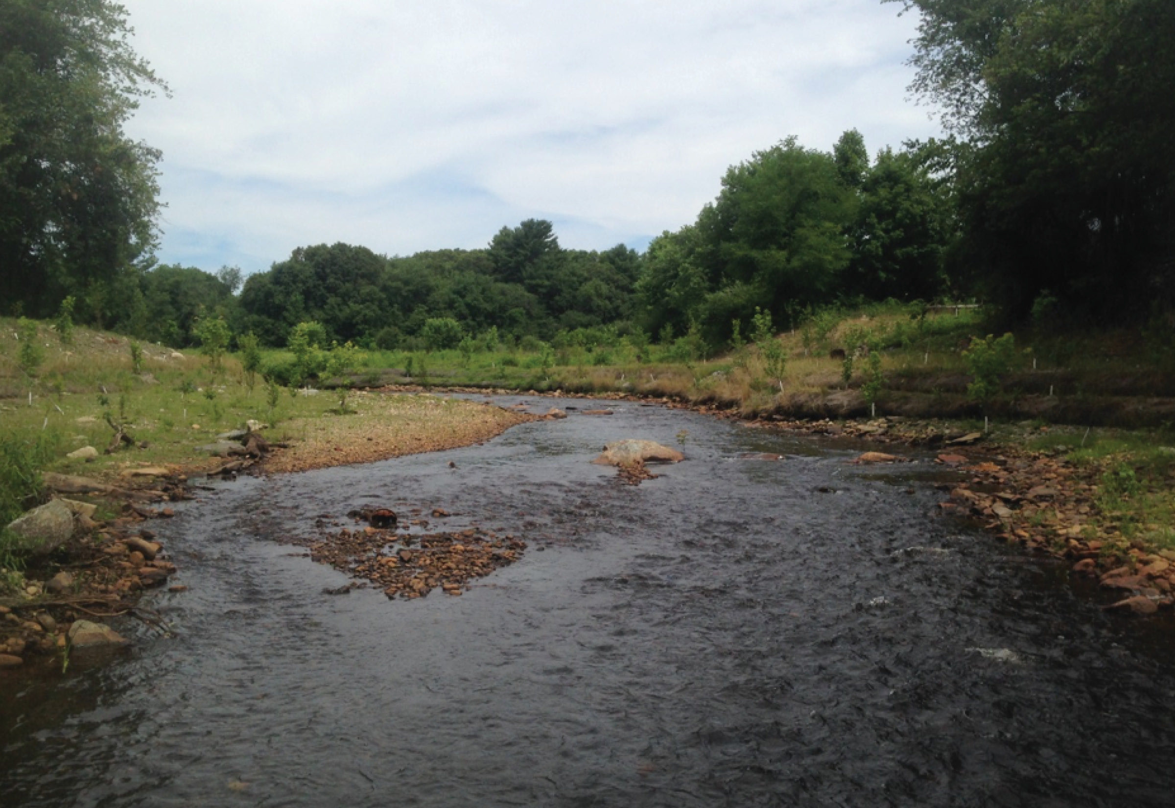
Solutions: In 2011, a project led by the Pawtuxet River Authority and Narragansett Bay Estuary Program, along with dozens of partners, used excavators to strategically demolish the concrete spillway. Native wetland plantings were installed along the newly exposed river banks to aid habitat restoration goals. Today, anadromous fish populations like river herring and American shad are once again able to travel upstream to spawn.
This project employed a process of ongoing public interaction, including advocacy on the part of a local business owner. Eight public meetings were held over four years, during which time, assessments and design plans were completed. During this process, the design was modified due to the bedrock conditions. The final design resulted in a portion of the dam staying in place to divert flow and fish in a way that promotes successful upstream migration.
Successes: A NOAA representative reflecting on the process asserted that the biggest hurdle was consensus-building. Ultimately, community consensus was reached, and for the first time in three hundred years, this section of the river was able to flow freely into Narragansett Bay, restoring 7.5 miles of spawning habitat above the dam.
Lessons Learned: For highly visible dams, the public process is very important to build an understanding of the project trade offs and the varying community interests.
Source: Inter-Fluve
CASE STUDY: Mill River Dams
Location: Mill River, Massachusetts
Goal: Reduce flooding risk, migratory fish passage, recreation and habitat enhancement
Owner: Acuity Management (West Britannia Dam)
Type: Complete Removal of two dams; Reconstruction of one dam
Cost: 1,574,000 (estimated total)
- West Brittania Dam removal: $354,420
- Whittenton Dam removal: $650,435
- Morey’s Bridge Dam ( dam reconstruction, fish ladder/eel ramp installation): $4.3 million (includes cost of bridge replacement)
Year: Hopewell Mills 2012; Whittenton 2013; West Britannia 2018
Primary Partners: The Nature Conservancy, NOAA, American Rivers, the Coastal America Foundation, the National Oceanic and Atmospheric Administration, the Massachusetts Division of Ecological Restoration, U.S. Fish & Wildlife Service, the Massachusetts Division of Marine Fisheries, Southeastern Regional Planning and Economic Development District, Save the Bay, USDA-Natural Resources Conservation Service, MA Department of Mental Health, MA Department of Transportation, Mass Audubon, Taunton River Watershed Alliance, Corporate Wetlands Restoration Program, Acuity Management and other dam owners.
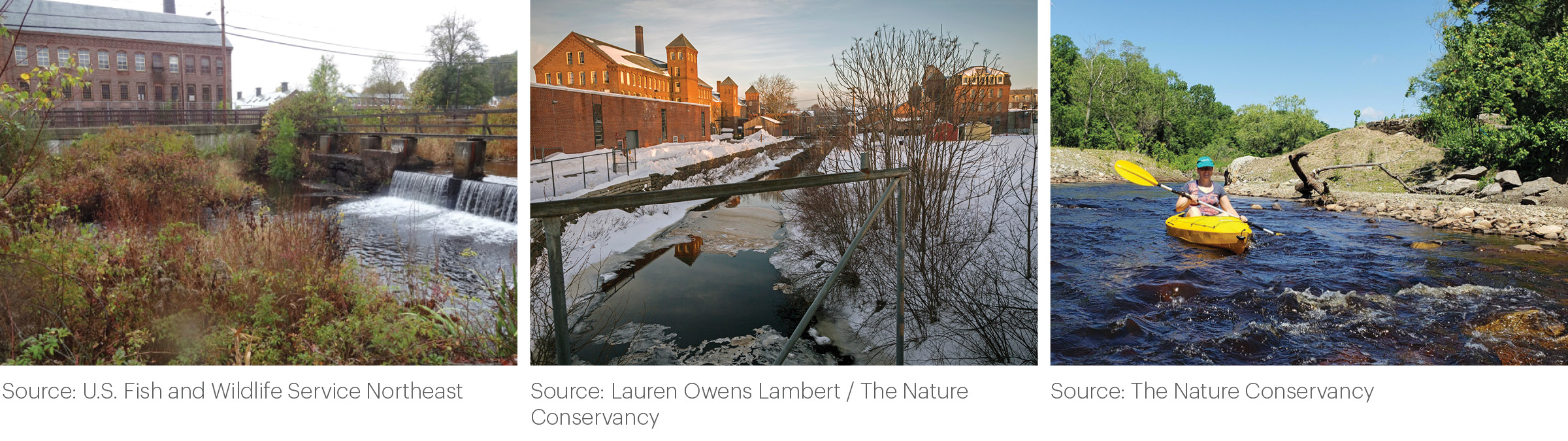
Context: Mill River, a 4-mile long tributary of the Taunton River, historically provided habitat and spawning grounds for migratory and resident fish, such as river herring, yellow perch, chain pickerel, American eel, and trout. The river was an active fishing location for native peoples for centuries until their forced removal from the area. At that point, colonists constructed a series of dams, which provided water and power to settlers, but cut off major fish runs. As a result of these obstructions and pollution from upstream manufacturing, a Massachusetts state report declared the river “dead” in terms of alewife population in 1921. In 2005, the decaying Mill River Dams were thrust into the national spotlight when Whittenton Dam nearly failed, forcing thousands of local residents to evacuate their homes and costing the city close to $1.5 million. Failure of the dam was narrowly avoided in this case, but community and regulatory attention turned toward finding solutions as dam failure may have led to major loss of life and property in downtown Taunton.
Challenges: Because multiple dams (West Brittania, Whittenton, and Morey’s Bridge) were involved in this project, each had its own set of challenges.
Solutions: In response to the near dam failure, risk posed to the surrounding communities, and an effort to reconnect the area to the Wild and Scenic Taunton River, three dams were removed over a series of years:
- Hopewell Mills in 2012
- Whittenton in 2013
- West Britannia in 2018
- Morey’s Bridge Dam was left in place, but a fish ladder and eel ramp was installed in 2012 as part of a bridge restoration project through the Department of Transportation
Successes: With a release of natural sediment held back by the dams, the river has begun to restore its natural channel, with increased biodiversity, and recreational access from the Narragansett Bay to the headwaters of the Mill River. The dam removals and reconstruction restored fish passage to 30 miles of habitat in the Taunton Watershed. River herring and sea lamprey have been reported in the area for the first time in 200 years. The project has also improved recreational access and reduced flooding threat to local communities–and has spurred secondary projects like the Weir Village Riverfront Park, which provides a waterfront walkway, boat ramp, and fishing pier.
Lessons Learned: The near-failure of the Whittendon Dam highlighted the dangers of neglected historic dams. Repairing the Whittenton Dam alone would have cost an estimated $1.9 million. The cost of removing the dams, restoring the river, and reducing dangerous hazards was far less costly and provided more beneficial outcomes for local residents and habitats along this stretch of the Mill River.
The Mill River Dams are a good example of the benefit of taking a “river approach” to addressing dams to improve habitat connectivity. Rather than only repairing or removing the failing Whittenton Dam, the team used the crisis as a catalyst to address multiple decaying dams along the Mill River and as a result were able to improve habitat connectivity along 30 miles of the river.
Removing the Dam Barrier While Preserving Historic Features
In some cases where removal is being considered, the dam may be perceived as an important part of the local landscape and cultural history. There are design strategies that can help maintain a sense of place and/or preserve portions of the historic structures while restoring a free-flowing river.
Some examples include:
- A portion of the dam structure can be preserved on either side of the river channel to mark the historic location of the dam.
- The location of the dam can be marked with a piece of public art that can tell the history of the dam and site.
- The river can be diverted around the dam, but the structure can be preserved.
- Other features can be added that maintain the aesthetics of the dam and public access can be provided in the area surrounding the dam.

Case Study: Kent Dam and Waterfall, Cuyahoga River
Location: Kent, Ohio
River: Cuyahoga River
Goal: Improved water quality, Historic preservation, Migratory fish passage, Aquatic habitat
Type: Partial removal with historic preservation
Cost: $5,013,150
Year: 2005
Partners: The Ohio EPA; Kent Dam Advisory Committee (KDAC); The City of Kent.
Context:
Although outside of the Narragansett Bay watershed, the Kent Dam case study is a useful example of a project that provided habitat connectivity, improved water quality, and historic preservation of a dam structure. The Cuyahoga River in Kent, Ohio has been a vital resource for people of the river valley since approximately 9,000 BC–acting as a travel corridor, water supply, and hunting and fishing grounds. The arch-shaped Kent Dam was constructed in 1836 to power various mills in the rapidly-industrializing Kent area. Because it is the oldest masonry dam in Ohio and the second oldest arch-shaped dam attached to a canal lock in the US, it has become an iconic feature of the city. However, after falling into disuse in the early 20th century, it caused dam pool stagnation, obstructed fish passage, and led to other water quality issues. The nation’s attention was drawn to the Cuyahoga River in 1970, when industrial and sewage waste caused the river to catch fire. This event, along with others across the country, spurred the adoption of the Clean Water Act, which was passed in 1972 in an effort to “restore the chemical, physical and biological integrity of the nation’s waters.”

Challenges: The stretch of the Cuyahoga River that ran through the defunct Kent Dam was cited for noncompliance with the Clean Water Act by the Ohio EPA for exceeding pollutant concentrations. The EPA informed the City of Kent that they must pursue a modification-removal of the dam or face more stringent permitting limits at the City’s Water Reclamation Facility. Because this permitting would be costly to Kent taxpayers and have little benefit to the quality of the river, the City of Kent began the processes of review and public engagement necessary to remove the dam with historic preservation.
Solutions: Due to the potential conflict between historical preservationists and environmental advocates, the city created a 19-member Kent Dam Advisory Committee (KDAC). Their goal was to examine feasibility and decision-making pathways by studying factors like applicable laws and regulations, water quality issues, historical significance, and fish migration routes. After several meetings, the KDAC proposed a solution: the removal of a concrete wall that had been placed across the old lock area. This removal would allow water to flow around the arch dam, which would improve water quality and allow fish passage while maintaining the historic arch structure. Tannery Park was constructed surrounding the historic arch dam and a pump circulates water so water continues to flow over the front of the dam.
Successes: By removing part of the dam to create a by-pass channel around the arch dam structure, the health of the river was restored without jeopardizing the historical aspect of the dam or interfering with the city’s identity. Since the partial removal of the dam, once-stagnant pools that emitted a foul odor are now flowing and allows for migratory fish passage. Dissolved oxygen levels at Kent Dam have improved. Also, the adjacent Tannery Park was expanded to allow increased public access to the historic landmark.
Lessons Learned: By creating an advisory committee dedicated to research and resolution, the project team was able to reach a solution that met the needs of the environment as well as the citizens of Kent. Because so much national attention was focused on the project, early involvement spurred the Clean Water Act, strategies of engagement, analysis, and implementation; it even helped to inform similar projects across the country.
The Kent Dam is also a good example of a project that was able to achieve the dual goals of habitat connectivity and historic preservation. By creating a public park at the dam site, the history of the site and sense of place was able to be preserved and possibly enhanced. In addition, by adding a water feature to the arch dam artifact, the aesthetic and acoustic experience of being near a waterfall was preserved.