Hazard Risk, Climate Change, and Dam Failure
Hazard Risk
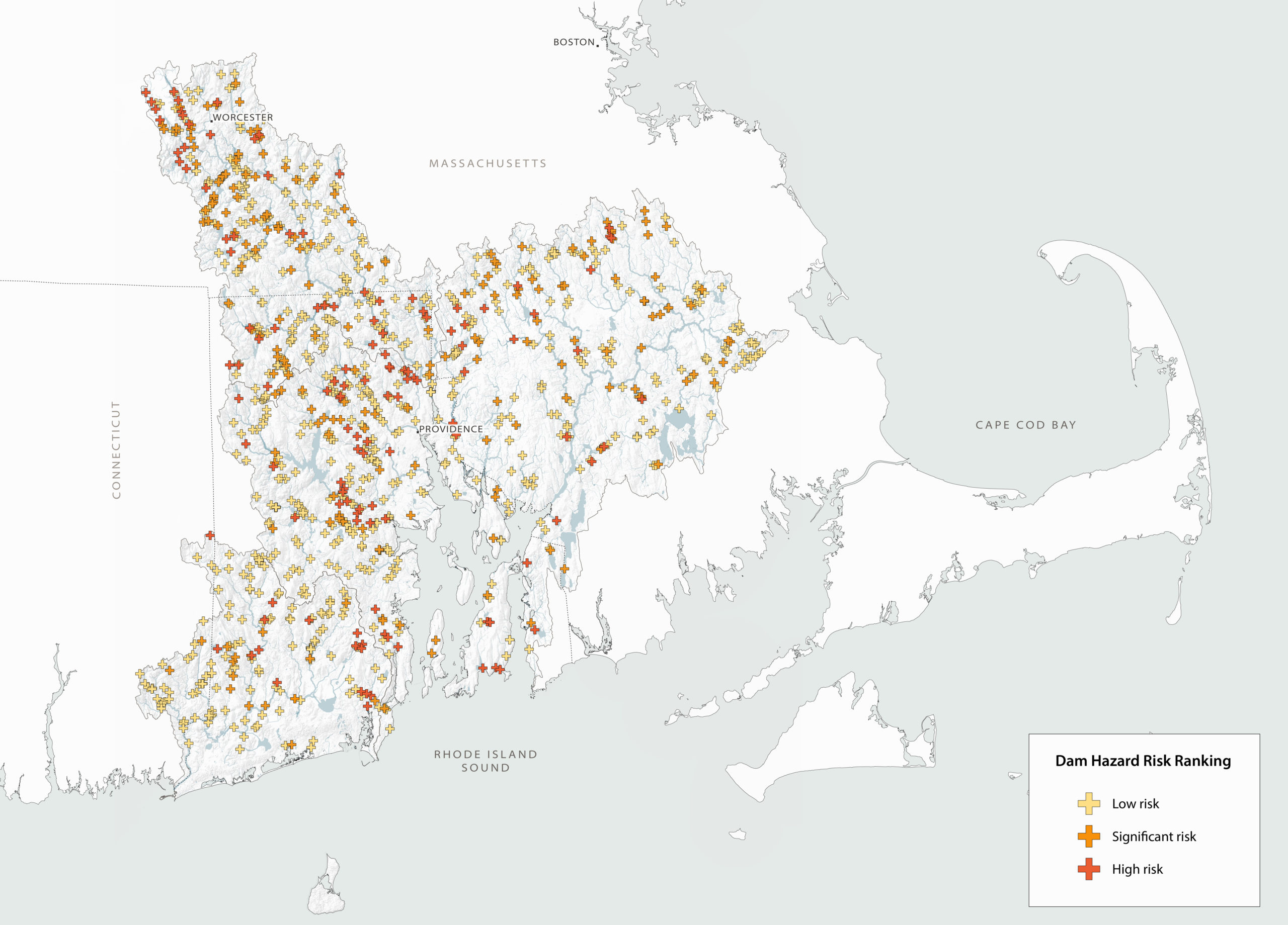
The majority of the dams within the Narragansett Bay and coastal watersheds were built over a century ago and are coming to the end of their lifecycle. Many dams have not been properly maintained or repaired over the years and would cause significant damage if they were to breach. Federal and state governments classify dams based on the potential impact of dam failure to downstream communities, infrastructure, and structures. Hazard risk does not consider the structural integrity of the dam — it just focuses on downstream consequences of failure.
There are 3 hazard rankings commonly used by Federal and State agencies:
High Hazard Dams: A dam where failure or misoperation would result in a probable loss of human life to communities downstream of the dam.
Significant Hazard Dams: A dam where failure or misoperation would result in no probable loss of human life but can cause major economic loss, disruption of lifeline facilities or impact other concerns detrimental to the public’s health, safety or welfare.
Low Hazard Dam: A dam where failure or misoperation would result in no probable loss of human life and low economic losses.
Within the Narragansett Bay and coastal watersheds, 55% of the dams do not have hazard data on record. Of the dams that do have hazard rankings within the watersheds, 31% of the dams are classified as high hazard dams, 45% are significant hazard dams, and 23% are low hazard dams.
Dams having low, significant, or high hazard risk within Narragansett Bay and coastal watersheds.
For more information about individual dams, please see the interactive map.
In both Massachusetts and Rhode Island, regulated dams include dams classified as significant or high hazard as well as low hazard dams that are six feet or more in height, or that have a storage capacity of fifteen acre-feet (note: an acre-foot is the volume of water of an area approximately 200 ft by 200 ft flooded to a depth of 1 foot). Dams less than 6 feet are unregulated.
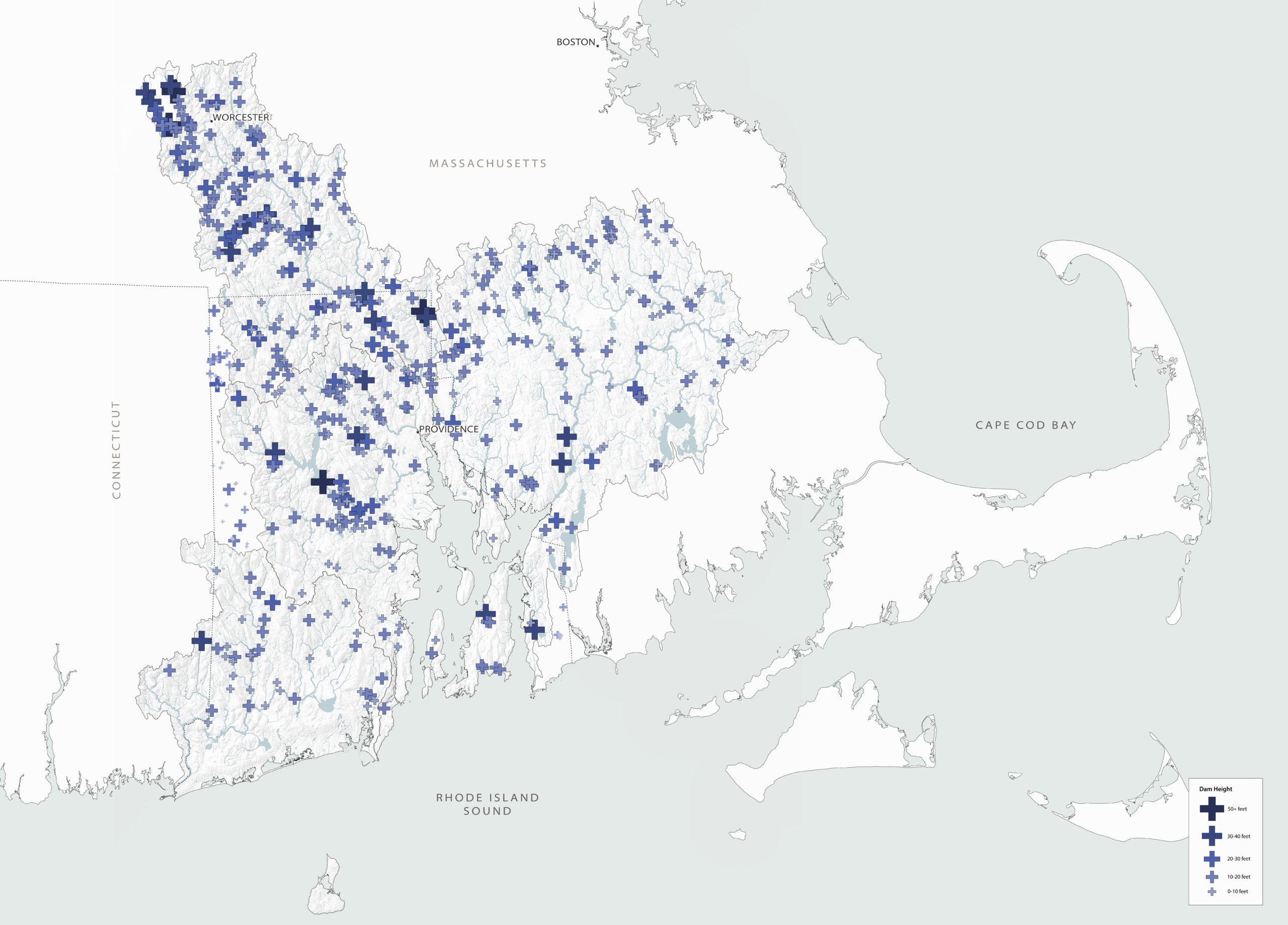
Energy production in the region is limited by dam size and river flow rate.
For more information about individual dams, please see the interactive map.
With the exception of hydropower dams that are regulated by the Federal Energy Regulatory Commission (FERC), there is no national standard for inspecting dams. The Department of Conservation and Recreation Office of Dam Safety regulates dams in Massachusetts and the Rhode Island Department of Environmental Management (RIDEM) monitors regulated dams in Rhode Island.
Within both states, an engineer must inspect and report results every two years for High Hazard Potential dams and every five years for Significant Hazard Potential dams. Within Massachusetts, Low Hazard Potential dams need to be inspected every ten years and in Rhode Island, Low Hazard Dams are required to be inspected every five years.
While the dam hazard ranking communicates the potential impact of dam failure on downstream communities, it does not consider the condition of the dam. When dam inspections are conducted, the condition of the embankment, spillway and low level outlet are ranked good, fair, poor or unsafe. Following the visual inspection, a dam inspection report is prepared, identifying specific deficiencies and, when warranted, recommending corrective measures. In Rhode Island, as of 2019, 54 high and significant hazard dams were identified as unsafe or potentially unsafe and received notice from RIDEM. By the end of 2019, safety issues at 5 of these dams had been addressed. Thirty-one additional high and significant hazard dams in RI were identified as unsafe or potentially unsafe but owners are unknown. Within the portion of the Narragansett Bay Watershed that is in Massachusetts, and that have available hazard data, there are 52 high-hazard dams. At this time, we do not know how many of the high-hazard dams in the Massachusetts portion of the study area are classified as being in poor or unsafe condition.
In addition to inspections, both states expect all dams classified as high and significant hazard to have an Emergency Action Plan (EAP). An EAP is a formal document that identifies potential emergency conditions at a dam and specifies pre-planned actions to be followed during an emergency to minimize loss of life and property damage. The EAP includes an analysis of downstream areas that would be flooded in the event of a dam failure, as well as mechanisms for alerting local emergency agencies and downstream residents if a dam failure is imminent. As of 2019, 31% of high and significant hazard dams in Rhode Island had approved EAP’s on record. At this time, we do not know how many of the high and significant hazard dams in the Massachusetts portion of the study area have approved EAP’s on record.
Climate Change
In addition to the risk associated with the age and lack of maintenance of the dams, there is a growing risk of failure due to extreme weather events. These historic dams were built at a time when severe weather was a rarity, not the norm it is becoming today. In addition, many were built when there were fewer established communities living in the flood zones downstream of dams.
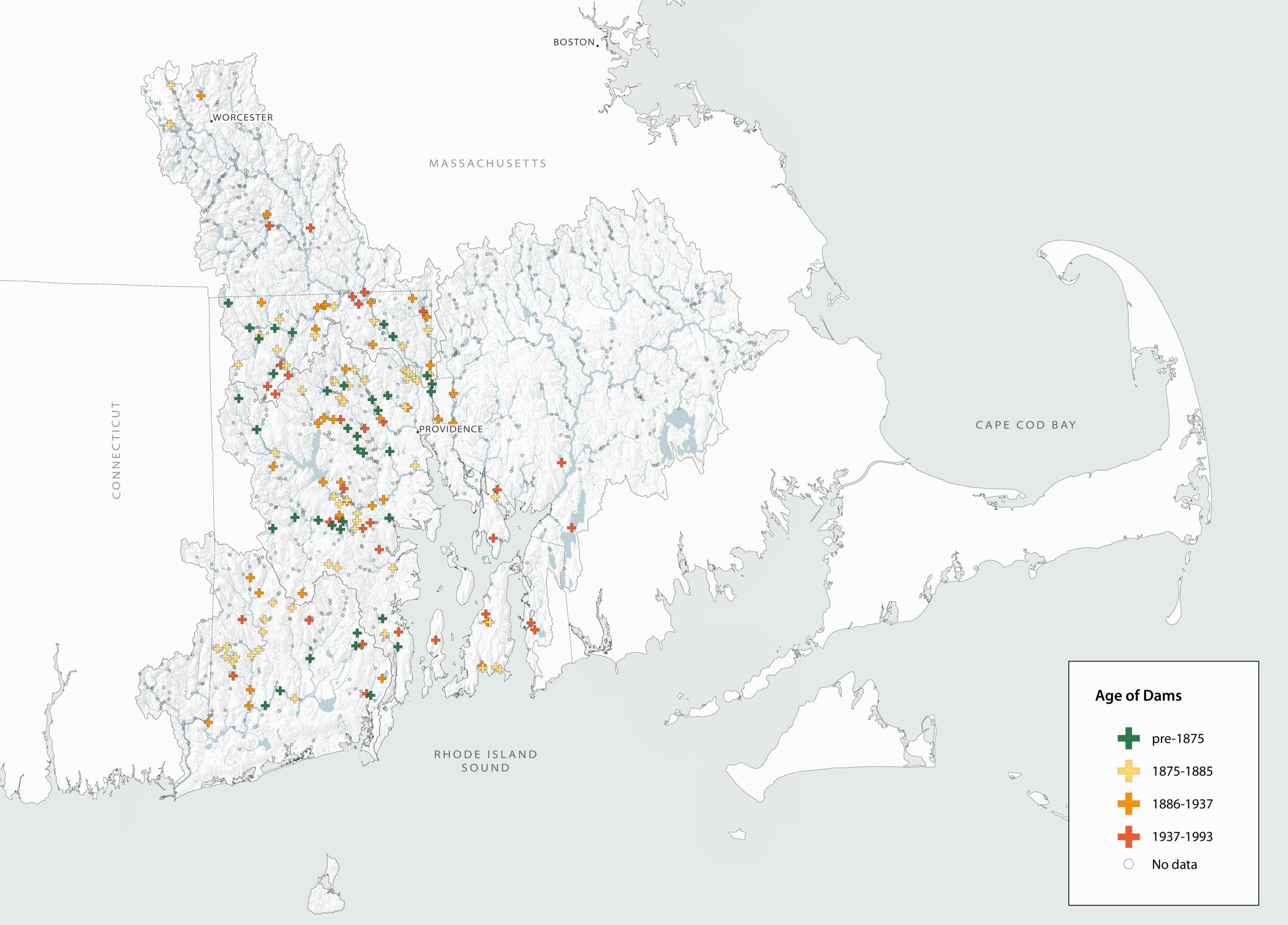
Age of dams within Narragansett Bay and coastal watersheds.
For more information about individual dams, please see the interactive map.
Climate change has altered many aspects of our lives, requiring reconsideration of our long-established national infrastructures, including dams. With the exception of the small number of dams that were constructed specifically for flood control, most dams in the Narragansett Bay and coastal watersheds do not provide flood control benefits. The risk posed by aging dam infrastructure is exacerbated by increasing annual precipitation along with increasing numbers of extreme precipitation events that can lead to flooding upstream of a dam and potential extreme and sudden flooding downstream if a dam fails. For example, the 2010 flood in Rhode Island inundated the state with more than 16.34 inches of rain falling during the month of March — the highest monthly precipitation on record. Many dams could not handle the excess flow and several dams within the region failed. Fortunately, these breaches did not cause loss of life. Similar dam failures around the country, including the failure of the Edenville and Sanford dams in Michigan in 2020, have led to millions of dollars in damages, and thousands of people whose homes were flooded.
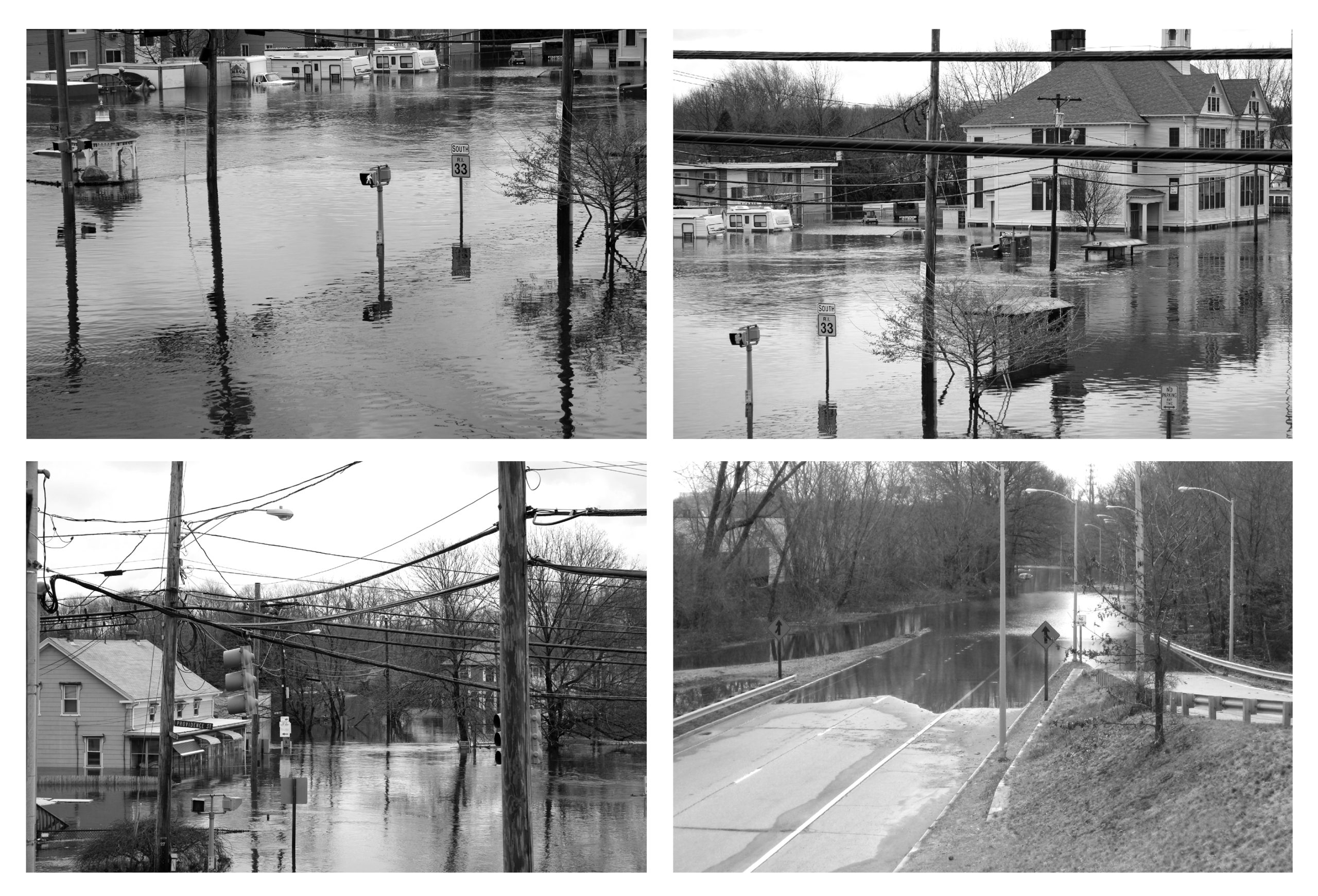
Record Flooding on the Pawtuxet River, March 31, 2010
Photo Source: National Weather Service Northeast River Forecast Center (link to original)
Dam Failure
Dam failure can be catastrophic — leading to loss of life, property and infrastructure. Dam failure is most frequently caused by water flowing overtop of the structure; foundation defects such as slope instability and settlement; and piping, resulting in internal erosion caused by seepage. Other causes may include structural failure of materials, settlement and resulting cracking, and poor maintenance.
Given the age of dams within the region, the increase in large storm events, and the potential risk of a dam failure on downstream communities, there is a need to ensure that local agencies have the resources needed to conduct regular inspections. In addition, while it is important that dams have an Emergency Action Plan on file to know how to react if a dam is failing, it is equally important for States to have adequate funding or other approaches that enable proactive preventative measures to address high and significant hazard dams that are in poor condition.